
BENEATH THE ROCKS
WILL WARASILA
Photography on view 9/17-10/20
616 EAST 9TH ST
M-F 10 am - 4 pm
Weekends by appointment
CATALOGUE - EMAIL FOR INQUIRES
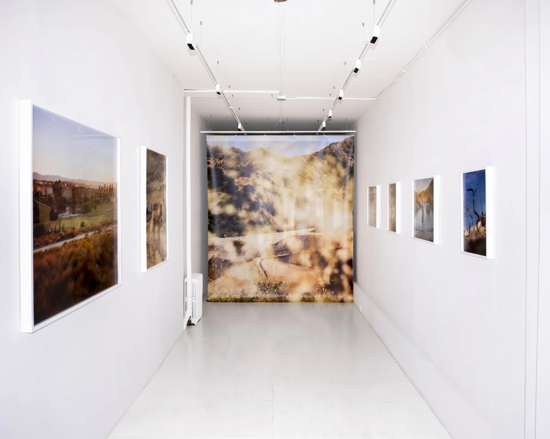
I am beyond thrilled to present Will Warasila’s first solo show in New York, and to invite you to join us at the opening reception on September 17.
Many of you will already know Will’s work as a contributor for the New York Times, where his photographs are frequently featured in print and on their account.
Outside of his reporting work and ongoing collaborations with design studios such as Terremoto Landscape and my own practice 000, Will has been working on several long-term documentary projects that examine the relationship between people, land, water, industry, and power. The first fruit of this effort, a monograph titled Quicker than Coal Ash, was published in 2022
Beneath the Rocks is a continuation of this exploration. In it, Will brings us scenes from Tujunga, a Los Angeles neighborhood conditioned by the mercurial presence of rainwater. The photographs — at once quotidian and spectacular — highlight the ingenuity and absurdity of life against cycles of long droughts and flash floods; conditions that will only proliferate and intensify as climate change comes for us all.
A companion text by Emma Kemp titled Ground Work will also be presented at the show, situating Tujunga and Will’s work within a critical and historical context.
Beneath the Rocks is on view at Studio 9BC (616 E9 St) from September 17 to October 20, with an opening reception on Thursday September 17, 5-8 pm.
-Jedy Lau, 000
GROUND WORK
BY EMMA KEMP
On Will Warasila’s Tujunga: Beneath the Rocks
More than a century before “the foothills” became a realtor’s promise of retreat from Los Angeles, Tujunga was already being sold as an elsewhere.
In 1913, advertisements for the Little Landers colony promised prospective settlers “A little land and a living. A paradise retreat. A veritable sanitarium.” The proposition was geographical but also ideological: leave the metropolis, acquire a small parcel, recover a more direct and self-sufficient relation to land. William Ellsworth Smythe and developer Marshall Hartranft established their Tujunga experiment on 273 acres, close enough to Los Angeles to recruit settlers from a downtown office but sufficiently removed to advertise a radically different way of life.
But the brochure soon ran up against the ground. The soil was extraordinarily rocky; digging even a few inches could mean excavating large boulders. Water arrived less as the promised abundance than as intermittence: scarce for long stretches, suddenly destructive when it came. Fire was a standing horizon. Many of the original lots were eventually absorbed into the speculative real-estate economy the colony had imagined itself escaping. Tujunga joined the City of Los Angeles in 1932.1
Will Warasila’s Tujunga: Beneath the Rocks begins somewhere inside this contradiction.
Tujunga belongs administratively to Los Angeles, occupying its northeasternmost edge where the metropolitan field runs hard against the San Gabriel foothills. The city does not end here so much as change texture. In Warasila’s photographs, the familiar grammar of Los Angeles loosens: sidewalks disappear; road shoulders become sediment; horses and chickens occupy residential lots; chain-link disappears into riparian growth; houses back into raw slopes. A market catches the last shard of sun. A liquor-store sign glows at dusk. Elsewhere, a pet cow occupies the yard of a steep-gabled suburban house.
This is not pastoral Los Angeles, although versions of it have repeatedly been marketed that way. Nor is it quite exurb, wilderness, suburb or city. Periphery here is less a measure of distance from the center than a condition of adjacency, one in which different systems press against one another, not always comfortably, yet remain simultaneously legible.
Warasila is especially attentive to these moments of imperfect fit. Across the sequence, boulders recur as creek material, property marker, garden architecture, riprap and obstacle. A figure walks away from the camera between a parked car and a small pile of cut wood; a horse presses against a metal rail; a dog steps into brown water among stones. Later, the frame opens onto the monumental geometry of a concrete flood channel before returning to sediment. Beneath transportation infrastructure, a blue tent sits against a mountain view so conventionally bucolic that the two refuse easy reconciliation. The photographs decline to rank what they encounter. Mountain and shopping strip; horse and highway; person and flood-control wall cohabit the same evidentiary field.
Beneath the rock, more rock: matter altered by time, then sorted again by human intention. Sacred site, building material, boundary, obstruction, shelter. Warasila returns repeatedly to these conversions without reducing them to static symbols. What changes is use, and with use, value.
In Tujunga, these negotiations over matter begin at the level of the ground itself.
The larger Tujunga drainage is one of the processes through which this part of contemporary Los Angeles was made. Before twentieth-century flood control, the San Fernando Valley floor contained active floodplains and alluvial fans. Seasonal streams descending from Big Tujunga and Pacoima canyons carried coarse material out of the San Gabriels and deposited it across the basin. The USGS describes a major Tujunga–Pacoima alluvial-fan system whose deposits have themselves been shaped by ongoing tectonic compression: late Pleistocene sediments cut by active faults, younger fans accumulating around land that is still deforming.2
An alluvial fan is less a thing than the residue of an action. Water leaves the confinement of a canyon, loses energy, drops its load of stone, gravel, sand and silt, then returns in another storm and rearranges the previous deposit. What appears from a distance to be stable ground is instead accumulated evidence of movement.
It would be easy to extend that geological process into a metaphor for the people Warasila photographs. But housing precarity is not a natural force. His subjects are not conscripted into allegories of environmental instability. The landscape conditions life here, certainly, but the photographs refuse the old documentary temptation to naturalize a social condition—to make displacement or marginality seem continuous with the terrain itself.
The distinction becomes more consequential when the ground is understood historically as well as geologically. Contemporary municipal boundaries lie across Indigenous geographies. The Fernandeño Tataviam Band of Mission Indians identifies Tujunga as a traditional place-name meaning “the place of the old woman,” associated with a sacred boulder, and situates Tujunga within a network of villages extending across northern Los Angeles County. The Kizh Nation likewise names Tujunga among the villages of its ancestral homeland in the Los Angeles and San Fernando basins.3 Against these older territorial histories, the city’s municipal geography appears recent, partial and contingent.
Fernandeño Tataviam accounts describe missionization, forced labor and subsequent land loss in northern Los Angeles. They also note the increasing value American institutions placed on lands possessing natural water sources. Rancho Tujunga appears within this history of contested Indigenous landholding and dispossession. Across the succeeding record, water is repeatedly redescribed by the institutions claiming authority over it.4
Los Angeles County created its Flood Control District in 1915. By mid-century, Hansen Dam, downstream from Big Tujunga Canyon, was in operation and sections of Tujunga Wash had been channelized, converting a mobile watercourse into the hard geometry of a conveyance system.5 The bargain was foundational to twentieth-century Los Angeles: channelization reduced flood risk across a developing valley by constraining many of the ecological processes through which the wash had previously accommodated water.
The concrete channel in Warasila’s sequence is governance in spatial form. Its apparent emptiness conceals an administrative proposition: that hydrological uncertainty can be engineered into civic predictability, that water can be separated from the ground through which it moves and sent efficiently elsewhere. Its rectilinear perspective invokes a fantasy that photography knows well: that to frame a force is to control it.
Today the same system performs a revealing counter-movement. Downstream in Sun Valley, the 150-acre Tujunga Spreading Grounds divert stormwater out of Tujunga Wash and into broad infiltration basins. A recent expansion replaced twenty smaller basins with nine larger ones and introduced inflatable dams and intake structures designed to slow and spread water so that it can recharge the San Fernando Groundwater Basin; LADWP estimates an average annual recharge of roughly five billion gallons.6 After a century largely devoted to accelerating water away from inhabited land, Los Angeles now invests in infrastructure designed to slow it, spread it, let it sink.
Warasila’s photographic method proceeds by a related refusal of speed. Relationship precedes exposure; research is not applied afterward as an explanatory caption but allowed to alter what the photographer sees, whom he photographs, and how long he stays. His practice begins from the premise that documentary photography cannot absolve the photographer of where he stands. The question is not whether the camera has a point of view, but what relations produced that point of view and to whom it remains accountable.7
This places Warasila within a critical documentary tradition that has spent much of the last half-century dismantling photography’s alibi of neutrality. One of that tradition’s central propositions has been that documentary evidence does not merely appear: it is selected, framed and circulated through relations of power.8 Warasila inherits that distrust of the innocent document without making the individual photograph carry the entire burden of argument.
His images are less declarative than cumulative. He is too interested in people for landscape to become detached typology, and too interested in systems for portraiture to collapse into humanist anecdote. Meaning builds laterally, through sequence. A portrait of an older man is surrounded elsewhere in the edit by dry vegetation, creek stone, domestic enclosures and retaining structures; attention continually moves away from the sovereign human face and back toward the conditions in which a face appears.
If no single image is required to deliver an argument, where does a documentary position reside?
Partly in the terms of inclusion—in what the photographer agrees to count as evidence. This is where Beneath the Rocks takes its stand.
Evidence here includes the concrete channel and the water escaping its bounds; a brilliant green fairway and the chaparral rising beyond it; the fenced animal and the fenced property; a person resting in afternoon light; a stand of weeds; a boulder around which some human arrangement has been improvised. Warasila does not present these as a catalogue of local eccentricities. Through accumulation, they disclose the neighborhood’s political form.
The photographs also resist a more seductive documentary failure: the romance of the fringe. Peripheries often invite projection from the center. They are repeatedly made to signify freedom from regulation, closeness to nature, or some ambiguous notion of authenticity. Tujunga has endured versions of this projection since the Little Landers advertised their “paradise retreat.” Warasila withholds the consolations of both ridicule and nostalgia. His photographs permit incompatible realities to remain unreconciled.
The governing proposition of Beneath the Rocks is stark: landscape photography against scenery. Warasila pushes the idea beyond the familiar injunction to look more closely at nature. Landscape is one of the forms politics takes. Political decisions acquire grade, texture, material weight; eventually they become difficult to distinguish from topography.
Seen this way, Tujunga’s position at the edge of Los Angeles is not marginal to the city at all. It is diagnostic of it. At the periphery, the technologies required to make “Los Angeles” appear stable are easier to see because they have not yet disappeared into the metropolitan background.
Here, mountain is subdivided into parcels; when the development burns, the parcel returns to dirt; the wash is straightened into a channel, then repurposed as groundwater-recharge infrastructure. Rain is a hazard, a resource, then back again. Rock carries meanings no municipal vocabulary can exhaust. Different systems of value remain active on the same ground.
Warasila’s photographs do not uncover an authentic Tujunga concealed beneath these layers. There is no pristine landscape underneath the infrastructure. What they register instead is a field of pressure: tectonic, hydrological, historical, civic, intimate.
The city can engineer for stability; it cannot make the ground still.
The earth continues its work.
_____
ENDNOTES
Ground Work: On Will Warasila’s Tujunga: Beneath the Rocks
“Little Landers Plans Announced,” Los Angeles Times, March 16, 1913, quoted in Hadley Meares, “Bolton Hall: The Little Landers of Tujunga and the Boom and Bust of a Utopian Garden City,” PBS SoCal, September 20, 2013. Meares’s account, drawing extensively on contemporary Los Angeles Times reporting and advertisements, documents William Ellsworth Smythe and Marshall V. Hartranft’s 273-acre Tujunga colony, its downtown Los Angeles recruitment office, the difficulty of cultivating its rocky ground, water scarcity, the eventual sale of many parcels during the 1920s real-estate boom, and Tujunga’s annexation by the City of Los Angeles in 1932.
R. F. Yerkes, Preliminary Geologic Map of the San Fernando 7.5' Quadrangle, Southern California: A Digital Database, U.S. Geological Survey Open-File Report 97-163 (1997), doi:10.3133/ofr97163. Yerkes describes the pre-flood-control San Fernando Valley floor as a system of active alluvial fans and floodplains, with coarse sediment carried from Big Tujunga and Pacoima canyons.
Fernandeño Tataviam Band of Mission Indians, “Opening the Pakoinga (Pacoima) DMV,” November 19, 2019; Gabrieleño Band of Mission Indians–Kizh Nation, “The Ancestral Territory of the Kizh,” and “Kizh Nation,” accessed August 14, 2026. The Fernandeño Tataviam source identifies Tujunga as a traditional place-name meaning “the place of the old woman,” associated with a sacred boulder bearing the form of an old woman. Kizh Nation materials likewise identify Tujunga among the Nation’s ancestral villages and describe a broader homeland encompassing the Los Angeles River watershed and extending north to the San Gabriel foothills. The two contemporary tribal accounts are retained here without attempting to collapse overlapping territorial histories into a single or comprehensive attribution.
Fernandeño Tataviam Band of Mission Indians, “LA River: Siutcanga,” October 19, 2021; see also Fernandeño Tataviam Band of Mission Indians, “History,” updated November 29, 2025. The Tribe’s historical account describes enslavement and forced baptism at Mission San Fernando, subsequent Fernandeño land grants—including Rancho Tujunga—and the dispossession that followed American control of California. It specifically identifies access to natural water sources as a factor in the increasing value of Indigenous-held lands in northern Los Angeles County and describes water as both sacred kin and central to the history of land dispossession.
U.S. Army Corps of Engineers, Los Angeles District, Hansen Dam Basin Master Plan and Environmental Assessment (2011), 10-4–10-5; U.S. Army Corps of Engineers, Hansen Dam Water Control Manual (1990). The Los Angeles County Flood Control District was created on June 12, 1915. Hansen Dam was constructed in 1939–40 and completed in September 1940 as part of the region’s expanding flood-risk-management system. Subsequent channel improvements transformed Tujunga Wash downstream of the dam into a concrete flood-control conveyance; major portions of the channel were completed by the early 1950s.
Los Angeles Department of Water and Power, “Tujunga Spreading Grounds Enhancement Project,” accessed August 19, 2026. The 150-acre facility in Sun Valley captures stormwater from Tujunga Wash for groundwater recharge. Its recent reconstruction consolidated twenty spreading basins into nine larger basins and added two inflatable rubber dams and new intake structures. LADWP estimates that the enhanced system can deliver an average of approximately five billion gallons annually to the San Fernando Groundwater Basin.
Will Warasila, “On Following Rabbit Holes,” conversation with Caitlin McCann, The Creative Independent, June 19, 2024. Discussing the beginnings of Quicker than Coal Ash in Walnut Cove, North Carolina, Warasila describes leaving his camera in the car during his first encounters with residents, developing relationships before photographing, and asking how documentary photography might materially serve a community confronting Duke Energy. He subsequently produced Faces of Walnut Cove, combining portraits with residents’ testimony and demands, before moving toward the more subjective and lyrical photographic language of Quicker than Coal Ash. Elsewhere in the interview, Warasila characterizes his deliberately slow method as a way of allowing relationships—and an understanding of what lies beneath the surface—to develop over time.
On the critique of documentary neutrality that informs the critical tradition invoked here, see Martha Rosler, “In, Around, and Afterthoughts (On Documentary Photography),” in 3 Works (Halifax: Press of the Nova Scotia College of Art and Design, 1981); and Allan Sekula, “Dismantling Modernism, Reinventing Documentary (Notes on the Politics of Representation),” The Massachusetts Review 19, no. 4 (Winter 1978): 859–883, subsequently collected in Photography Against the Grain: Essays and Photo Works, 1973–1983 (Halifax: Press of the Nova Scotia College of Art and Design, 1984).